Version History
Here you can find the changelog of XC Guide since it was posted on our website on 2017-01-01.
The latest version is and it was updated on soft112.com on 19 April, 2024.
See below the changes in each version:
version N/A
posted on 2024-03-07
V558 7 Mar 2024
Android battery optimisation and background App restriction will be detected by the App on start-up and highlighted to the pilot.
It is strongly recommended to remove these restrictions when running XC Guide.
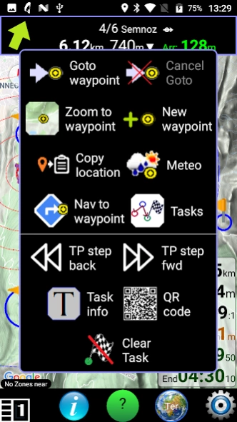
A new airspace feature prepares the CTAF (airband VHF traffic) phraseology, in English, when an ATZ (circle) is clicked on the map.
Competition tasks from xcontest cloud, (with a 4-digit name), can now be loaded directly into XC Guide from the Navigation menu.
version N/A
posted on 2023-11-04
V552 4 Nov 2023
The Volandoo live-tracking service is now supported.
Volandoo flying status and wing type are also shown in tracker status.
Improved wind calculation
MipBip+ and MipBipS+ varios both supported correctly
version N/A
posted on 2023-08-21
V542 19 Aug 2023
Target SDK 33 (mandatory change for Google Play Store)
Notifications permission fixed on Android 13 phones
version N/A
posted on 2023-07-06
V540 6 July 2023
Minor fix for Air3 7.3+ FANET / FLARM modules to support latest FLARM firmware.
version N/A
posted on 2023-06-18
V538 18 June 2023
Easy Airspace download from XContest.org
Click on any Airspace to exclude it individually or the entire class.
A long-press anywhere on the map can create a temporary "EZ_GOTO" waypoint and start navigation.
When editing a race task, the correct local time-zone is provided.
Bug fixes / performance improvements.
version N/A
posted on 2023-04-19
V532 19 Apr 2023
New screen layout 'swiper'
Double click swiper for 'home' layout.
Long-click swiper for layout settings.
New user-defined Fn button.
Single or double tap actions.
Long-click Fn button for action settings.
New Station Finder navigation mode
Updated Polish user guide
More stable XC-Tracer Maxx2 Bluetooth link
version N/A
posted on 2023-03-16
V516 16 Mar 2023
There are now 5 screen layouts.
The square Layout and Android 'Back' buttons step forward / back.
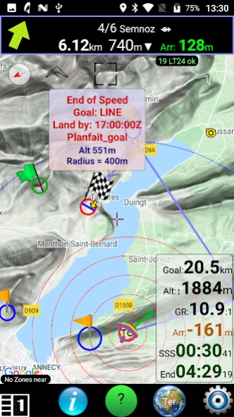
A task create / edit wizard has been added,
for designing classic race tasks.
IGC files from XC Guide are approved by CIVL for CAT 1 events.
Club Waypoint Challenges supported.
SPOT and inReach trackers can be selected individually.
Split screen mode is supported,
i.e. share the screen with another App.
Files (Waypoints / Airspace / Hotspots) can be selected individually.
version N/A
posted on 2022-04-29
V440 29 April 2022
Telegram group location sharing with XC Guide is now supported using the XCView.net service.
Once the XCView.net 'bot' is added to your group, it accepts these status commands:
/sos
/retrieve
/ok
which trigger alerts in the App.
Text messages (pre-set or custom) can be sent from XC Guide into the Telegram group.
ADS-B traffic received via a SkyEcho2 is included in the localhost feed to other Apps.
Fixed bug on Android 12, where back button did not close App properly.
version N/A
posted on 2022-04-06
V434 6 April 2022
New Google map renderer is available in Map settings.
But beware it can cause low-memory crashes after a few hours.
GxAirCom $LK8EX1 sentences are forwarded via Localhost.
Race tasks: multiple start gates now supported.
Terrain height AMSL for your area is loaded automatically from pg-race.aero/agl/
Terrain can also be loaded for anywhere else with a long-press on the map coordinate window.
version N/A
posted on 2022-03-23
V432 23/03/22
Bug fix for Air3 7.3+ FLARM firmware upgrades
Thermal assistant bug
Adjacent terrain tiles are loaded automatically when you are close to the edge of a tile.
version N/A
posted on 2022-03-14
V422 14 Mar 2022
Altitude above ground level (AGL) tiles are automatically downloaded and cached by the App from pg-race.aero/agl/
The Airspace Elevation view now shows ground profile.
Airspace Zones (polygon) or ATZs (circle) using height above ground level 'AGL' are automatically re-calculated using the terrain cache.
Airspace Zones (polygon) or ATZs (circle) using Flight level 'FL' are automatically re-calculated using barometric reading (from BLE vario or internal sensor).
Bug fixes.
version N/A
posted on 2021-11-13
V390 12 Nov 2021
New file management tools in the Help menu ('?' button).
Now you can easily Copy, Share, Rename & Delete files within the XC Guide folders /Android/data/indysoft.xc_guide/files/
If a file is changed in the Airspace, Waypoint or Hotspot folders, the map is updated without need for an App re-start.
Bug fix for Android 12 (S) when using BLE devices.
version N/A
posted on 2021-10-20
V384 20 Oct 2021
The Bluetooth vario MipBip+ is now supported via BLE.
Your XC-Tracer FLARM Radio ID is shown in App status.
FLARM licence expiry will also be shown.
New Livetrack24 tracking modes:
1) Tracking from each takeoff to landing
2) Tracking continuously - 'Hike and fly' mode.
3) Tracking from App start until first landing
New Chinese user guide.
'Hike and fly' continuous IGC and KML logging is also now available.
XC Guide now supports Android 12 (S)
version N/A
posted on 2021-08-21
V372 21 Aug 2021
View a flight (as KML) in Google Earth.
View active race task in Google Earth (as KML).
Airspace to KML - new option to only convert displayed, filtered airspace.
Bug fix: Sharing diagnostic logs, weather forecasts & IGC or KML files didn't always work.
Race tasks: New option to optimize path to ESS then optimize to goal.
Livetrack24 radius search increased to 200km.
version N/A
posted on 2021-08-19
V366 19 Aug 2021
View a flight in Google Earth (KML), via the Flight Logbook & Help menu.
View active race task in Google Earth (KML), via the Navigation bar, Waypoints & Tasks menu.
Bug fix: Sharing diagnostic logs, weather forecasts & IGC or KML files didn't always work.
Race tasks: New option to optimize path to ESS then optimize to goal.
version N/A
posted on 2021-08-12
V360 12 Aug 2021
XC Guide is now able to handle FLARM using GxAirCom FANET modules (firmware v4.11.2 or later).
FLARM traffic within range can be included in the Pilot List and on the map.
FLARM, for all aircraft types, can also be shown when using an XC-Tracer (firmware R09+).
Minor bug fix: In all screen modes the map now appears immediately.
version N/A
posted on 2021-07-06
V353 6 July 2021
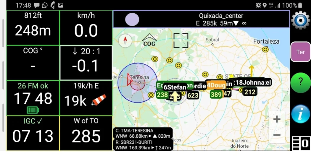
XC Guide can show ADS-B traffic from the provider OpenSky.
Transponders at different ranges and altitudes can be filtered out.
Map marker prominence now reflects the state of each tracker.
E.g. Trackers with an SOS are on top, others below.
Improved FlyMaster Group ID updates when used on narrowband, high latency mobile networks.
If navigating to retrieve a landed pilot but meanwhile the pilot moves > 0.5km, an alert is played to the driver.
version 1.346
posted on 2021-06-21
V346 21 June 2021
To reduce the load on the Livetrack 24 servers, tracking unknown pilots nearby (i.e. in 'radar mode') is limited to a 100km radius and query rate is max once per minute.
Live-tracking into Livetrack 24, however, can simultaneously use the faster query rate of 10s (2s with high-res tracking).
Supports Min SDK 19 (Android 4.4 KitKat and above)
App is checked against the latest version on XC Guide homepage;
https://pg-race.aero/xcguide/
version 1.345
posted on 2021-06-20
V345 20 June 2021
To reduce the load on the Livetrack 24 servers, tracking unknown pilots nearby (i.e. in 'radar mode') is limited to a 100km radius and query rate is max once per minute.
Live-tracking into Livetrack 24, however, can simultaneously use the faster query rate of 10s (2s with high-res tracking).
Supports Min SDK 28 (Android 9 and above)
Latest App version is checked against the XC Guide homepage;
https://pg-race.aero/xcguide/
version 1.341
posted on 2021-06-15
V341 15 June 2021
Introduces some protective limits to reduce load on the Livetrack 24 database.
In particular: Tracking unknown Livetrack 24 pilots nearby (i.e. in 'radar mode') is now restricted to a 10km radius and limited to tracking update rates of 60 seconds or more.
Supports Min SDK 29 (Android 10 and above)
Latest App version is checked against the XC Guide homepage;
https://pg-race.aero/xcguide/
version 1.338
posted on 2021-06-05
V338 5 June 2021
Bug fixes:
New OGN ID not always saved
MAC of BLE devices not always saved on first connection
First SkyLines pilot was sometimes missing.
BLE scan for XC-Tracer also accepts 'XCT' as BLE name
XC-Tracer wind estimate (stringToSend=LXWPW) is now sent via Localhost
Added IGC and diagnostic log file share facility in Help menu.
Min SDK 29
Latest App version is checked against the XC Guide homepage;
https://pg-race.aero/xcguide/
version N/A
posted on 2021-05-15
V324 15 May 2021
A FANET module (Lilygo T-Beam) can now be used as a GPS source for XC Guide.
The location service 'what3words.com' can be provided for each tracker in the Pilot List.
Improved tracker status window.
Reminder: App folders are in /Android/data/indysoft.xc_guide/files/
If un-installing XC Guide, these folders are deleted automatically.
Backup tracks & logbook etc. before un-installing.
version N/A
posted on 2021-04-27
V316 27/04/21
App now targets SDK 30 (Android 11 R) & min SDK is 19 (Android 4.4 KitKat)
Files permission is no longer required.
New Dutch & French user guides.
The Waypoints & Tasks sub-menu allows you to import or delete, tasks and waypoint files.
For XC-Tracer Maxx, use BLE name "XCT"
Bug fixes
Reminder: App folders are in /Android/data/indysoft.xc_guide/files/
If un-installing XC Guide, these folders are deleted automatically.
Backup tracks & logbook etc. before un-installing.
version N/A
posted on 2021-03-18
V300 18/03/21
New folder structure to comply with Android 11 (R) restrictions.
All XC Guide folders are now in /Android/data/indysoft.xc_guide/files/
The contents of the legacy /XCGuide/ folder are copied automatically and it is renamed to /XCGuide_old/
New "Quit App" option option under help menu.
Improved SOS & Retrieve alarm handling when App is running in background.
Improved FANET message log display
version N/A
posted on 2021-02-25
V292 25 Feb 2021
Profile changes (Guide | Pilot | Retrieve) now require the App to re-start.
A log of FANET messages can now be viewed in a conversation-style scroll.
New Paramotor fuel gauge uses spare ADC input to FANET modules.
Full-screen option now available in User Interface settings
A new FAI 28% Triangle helper, in the Tasks menu.
Pick any 2 waypoints (independent from race tasks)
Bug fixes
version N/A
posted on 2021-02-18
V290 18 Feb 2021
For improved stability, Profile changes (Guide | Pilot | Retrieve) now require the App to re-start.
All App settings can be different between each Profile 'personality'.
A log of FANET messages can now be viewed in a conversation-style scroll.
The scroll is accessed from the App Status Pop-up or the FANET message Pop-up.
New Paramotor fuel gauge.
Sensor i/p is ADC13 on HELTEC or LILYGO modules.
GXAirCom firmware 4.5.1 or later
New Garmin inReach endpoints
Bug fixes
version N/A
posted on 2021-02-04
V280 4 Feb 2021
FANET / GxAirCom support for the low-cost HELTEC Lora 32 board (without GPS)
New FANET configuration settings for transmit power, module name, aircraft type, flying-mode.
FANET-shared thermals now show on the Google map
GPX waypoint files now suppported (e.g. sites exported from ParaglidingEarth.com)
version N/A
posted on 2021-01-21
V266 21 Jan 2021
FANET is now supported, using GxAirCom (LoRa / Bluetooth) modules.
Any FANET device within range, will appear in your Pilot List and on the map.
Module status is shown in the App status window.
FANET message options include pre-set messages & custom (inc. emojis).
"SOS" and "Need retrieve" messages trigger alerts when received by XC Guide.
FANET weather reports appear on the map automatically.
Other:
Competition task QR codes can be scanned from an image
version N/A
posted on 2020-12-02
V246 1 Dec 2020
Improved support for Android 10 Q
- continued tracking when App is in background
- better menu & list layouts
New 'Edit waypoint' button (from the Navigation bar) gives
- easy editing / deleting of any waypoint
- better integration with emoji markers
OGN filter: FNT* can be used to see FANET trackers
version N/A
posted on 2020-11-27
V244 27 Nov 2020
Skylines pilots can now also be tracked, within a range, or specifically by ID number or name.
Specific, named, OGN & Skylines trackers can be excluded from your visible Pilot List.
Bug fix affecting landscape mode.
version N/A
posted on 2020-11-25
V242 25 Nov 2020
Skylines pilots can now also be tracked, within a range, or specifically by ID number or name.
Specific, named, OGN & Skylines trackers can be excluded from your visible Pilot List.
version N/A
posted on 2020-11-20
V232 20 Nov 2020
The ADS-B transceiver SkyEcho2 is now supported.
XC Guide has a new 'Airtime saver mode' for limited bandwidth situations.
Permission for Contacts is only requested when one of the 3 Pilot List options is clicked which links trackers to phone Contacts.
The Open Glider Network OGN 'buddies' filter now shows aircraft types.
E.g. use a filter such as "FLR*" to show all FLARM trackers monitored by OGN.
Phone temperature °C/°F has been added to the Flight Computer.
version N/A
posted on 2020-10-23
V222 23 Oct 2020
XC Guide can now be started automatically on phone boot-up.
It can also operate as a local host live-tracking server.
This is included for dedicated flying instruments such as Air3.
Imperial measurements (miles / feet / fpm) if required, are implemented extensively throughout the App.
Plus bug fixes.
version N/A
posted on 2020-10-15
V208 14 Oct 2020
XC Guide can now automatically send an email to a list of addresses when you take off and land, including your safety status .
XC Guide now offers a local server, to which other Apps can connect, such as XCTrack and XCSoar.
This can allow live-tracking feeds to be shared in real time.
XC-Tracer and BlueFly ID's are saved, so only your devices connect on a busy takeoff.
Airspace files can be converted to .KML (for Google Earth) with a new button in the App Status window.
version N/A
posted on 2020-09-19
V202/203 18 Sept 2020
Android 'Go' Edition tablets, with low memory, are now supported.
XC Tracer can now be used (via Bluetooth BLE) for GPS location if your tablet has no internal GPS.
Any waypoint can now be customized on the map as a text label or emoji graphic icon.
Improved FlyMaster 'Landed' detection (green map marker)
version N/A
posted on 2020-09-07
V198 7 Sept 2020
Supports Android 'Go' edition (Oreo API 26 or higher)
Flymaster 'Landed' status (green marker) means
version 1.195
posted on 2020-08-27
V195 27 Aug 2020
Competition race task QR codes can now be read by front or back camera.
IGC files from XC Guide are accepted by FAI/CIVL and are verified by their online validation service.
Improved detection of landed, walking, driving or flying for FlyMaster trackers.
Co-ordinates of the Map centre can be shown as Lat/Long, UTM or OSGB.
version 1.193
posted on 2020-08-12
V193 12 Aug 2020
Competition race tasks now supported in XC Guide.
Tasks are compatible with the PG-Race.aero service, and can be loaded and shared via the Navigation tool
Camera permission is requested to scan QR codes for easy task sharing.
Task information is provided to guide a pilot around the optimized race route.
IGC files from XC Guide are accepted by FAI/CIVL and are verified by their online validation service.
Improved settings layout
version 1.183
posted on 2020-06-22
Version 183 - 22 June 2020
Xcontest accepts XC Guide's IGC files (since Feb 2020)
New Thermal Assistant feature.
Press the climb/sink box in the Flight Computer to change mode: "off", "on", "auto".
Improved Bluetooth BLE scanning for faster Vario and iTag re-connection
Airspace is now clickable, showing each zone base & top
Way-points can be sorted by distance from you.
The 'Frame all markers' button on the map can be made sticky with a long-press
Bug fixes
version 1.179
posted on 2020-02-20
Version 179 - 20 Feb 2020
New "Show KML file" option in Help menu '?'
Startup map location is your last location.
Pilot List & Nav Bar buttons have larger click area (better for gloves)
New "Navigate to waypoint" button
New Flight Computer option for Imperial units: Ground speed (mph), climb rate (fpm),
wind speed (mph) and distance from takeoff (miles)
Fixed bug: Livetrack24 not always getting Popup alerts.
version 1.176
posted on 2020-01-30
Version 176 - 29 Jan 2020
The 'Follow me' button in the top left of the Google map now has three modes:
Course up, Course Right or North up.
The Airspace Elevation (cross-section) view can now have the bearing rotated, when not flying, by turning the map with two fingers.
Fix for bug reported via PlayStore
version 1.174
posted on 2020-01-15
Version 174 - 15 Jan 2020
Weather forecast for a waypoint (OpenWeather(R)) now includes local sunrise and sunset times.
New IGC replay mode added under '?' menu.
E.g. to check wind strength and airspace proximity.
Flight computer turns pink during IGC playback.
Improved menu list appearance
Added XC Tracer FLARM health and versions to App Status popup.
Minor bug fixes
version 1.169
posted on 2019-11-18
Version 169 - 18 Nov 2019
Weather forecasts for any way-point now include dew point and cloud base, in metres AMSL (OpenWeather(R))
Any weather forecast can now be shared as a .jpg or .png file.
Forecasts are saved in /XCGuide/Meteo
Pilot List menu now includes a Google Navigate shortcut button.
App Status popup now shows which airspace/waypoint/hotspot files are loaded.
version 1.167
posted on 2019-11-03
Version 167 - 3 Nov 2019
Weather forecast for a given waypoint (OpenWeather(R))
Pilot List and Nav / Waypoint menus now use friendly icons.
New Portuguese, Italian and Hindi user guides
Default waypoints now in XCGuideWaypointsMy_waypoints.txt (easier to edit)
Bluetooth icon appears in Flight Computer when vario is connected
version 1.158
posted on 2019-10-09
Version 158 - 9 Oct 2019
Livetrack24 users can send each other messages.
On landing, a safety or retrieve message can be sent from a customized list.
SOS and Retrieve alarms can be triggered by Livetrack24 messages.
An envelope icon in the Pilot List indicates if any tracker messages are present.
FLARM (R) traffic is shown on the map.
When creating new way point, a pop-up allows you to Save a new name, Save & Goto or Cancel
version 1.148
posted on 2019-09-06
Version 148 - 6 Sept 2019
New German user guide (Deutsch).
Notification icon means GPS updates continue while the app is in background, (all versions of Android).
XC-Tracer FLARM(R) is now supported.
Audio and visual alarms are given if a collision is predicted.
The BlueFly bluetooth vario is now supported.
Use Mode 5 & outputFrequency = 10
A Bluetooth iTag button can be used to refresh the screen and change screen layout.
version 1.26
posted on 2018-01-16
Version 25 4 Nov 2017
1) Spanish user guide is now built-in
2) Takeoff now requires 10m altitude change
3) Fixes for bugs reported:
SPOT data feed is using new http response code
Some format variations in airspace files caused a crash
Version 26 16 Jan 2018
1) Improved airspace proximity measure
2) Can now set a mock location and altitude to test airspace zones
3) Takeoff detection bug fix
version 1.9
posted on 2016-12-08
Ver Code 9 Ver 1.9,1) Wind strength & direction now added to flight computer,2) IGC flight playback is now possible